A land surveying course description includes a combination of theoretical knowledge and practical skills in measuring, mapping, and analyzing land boundaries using mathematics, modern technology, and specialized software. These programs cover core topics such as cadastral and topographic surveying, geodetic principles, and land administration, with an emphasis on hands-on experience with equipment like total stations, GPS receivers, and CAD programs. Graduates are prepared for careers in construction, mapping, and land management.
Core components of a land surveying course
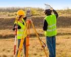
Measurement and data collection:
Learning to use instruments like total stations, levels, and GPS receivers to collect precise data.
Mathematical and computational skills:
Applying mathematics to calculate distances, areas, and coordinates, and to adjust survey data.
Mapping and analysis:
Creating topographic maps, performing spatial data analysis, and understanding geodetic principles.